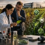
In a once-productive cornfield on the Delmarva Peninsula, the ground crunches underfoot with a white crust of salt. Bright green rows of young corn suddenly give way to barren, cracked earth where nothing grows. Farmers here have watched this creeping scourge worsen year by year: saltwater from rising seas is seeping into their fields, poisoning crops and turning good farmland into marsh. “When I bought this farm, this field was perfect. Now the tide comes in and out… at least half the time,” says Kevin Anderson, a Maryland farmer whose corn yields have plummeted as saltwater inundates his land. Anderson calculated one ruined acre cost him $650 to plant, and “nothing productive will come from that”. Stories like his are increasingly common in low-lying coastal regions, where what scientists call an “invisible flood” of salt is overtaking fields even on sunny days. The once invisible threat is becoming alarmingly visible – white salt patches scar fields, “ghost forests” of dead trees rim tidal creeks, and family farms fight to survive.
This slow-motion crisis, known as saltwater intrusion, has escalated due to climate change and sea level rise. The Delmarva Peninsula (encompassing Delaware and parts of Maryland and Virginia) is experiencing sea levels rising at three times the global average – compounded by land subsidence – which drives saltwater farther inland. During just a six-year period, from 2011 to 2017, the land area with visible salt damage on Delmarva nearly doubled, and roughly 20,000 acres of farmable land were transformed into marsh. “That’s pretty staggering, especially because the time period was small,” says Kate Tully, a University of Maryland researcher, noting that Delmarva may be just “a couple years, 10 years ahead of what folks are going to see in other parts of the world”. In other words, coastal farms here are the canary in the coal mine for a looming global challenge. Saltwater intrusion is often a precursor to outright flooding – which is why Tully calls it “the invisible flood” that strikes in advance of sea level rise’s full brunt.

Rising Salt, Sinking Yields
The impact on agriculture has been profound and sobering. As saline water infiltrates soil, it stunts crop growth and slashes yields by disrupting plants’ ability to take up water. Common crops like corn, soybeans, and wheat – the backbone of coastal Delaware and Maryland’s farm economy – simply cannot thrive in salty soils. “When salt comes into our fields, there’re places that won’t grow crops, nothing will germinate,” explains Dawson Pugh, a fourth-generation farmer in North Carolina’s lowlands. Wetter soils with elevated salinity become dead zones for conventional crops, leading to declining yields, soil degradation, and even pollution runoff as salt mobilizes nutrients and causes algal blooms in nearby waters. On the Delmarva Peninsula, many affected farms are part of the region’s $5 billion poultry-feed industry (growing corn and soy for chicken feed), so the stakes are high. Researchers found that even before a field is abandoned, salt intrusion can cut into profits: in fields within 200 meters of those telltale salt-crusted patches, yields drop enough to cost farmers an estimated $39–70 million in lost income every year across Delaware, Maryland, and Virginia. Eventually, if the salt encroachment continues, the land becomes unfarmable. In those same six years of study, about 19,000 acres of cropland turned into unproductive marshland in coastal Delaware, Maryland and Virginia – often dotted with the skeletons of trees killed by encroaching saltwater, the haunting “ghost forest” visible along tidal rivers.
The economic and cultural ramifications are profound. Farmland lost to salt means lost revenue and generational livelihoods uprooted. “It’s not something that just started, it’s been happening for generations, and it’s getting worse,” farmer Pugh says of the slow inundation of North Carolina’s coastal plain. Nationwide, saltwater intrusion has already contaminated freshwater aquifers in 43 U.S. states, threatening not only crops but drinking water supplies. In the Mid-Atlantic alone, roughly 28,000 hectares (69,000 acres) of farmland – an area about three-quarters the size of Philadelphia – were identified by researchers as “at-risk” by 2017 due to nearby salt patches, a doubling from just a few years prior. Soil salinity is creeping into fields that a decade ago grew healthy soy or corn, and each salty patch often signifies a much larger area of subprime soil around it that may still look normal but yields poorly. As Pinki Mondal, a University of Delaware scientist who led a recent mapping study, put it: “What we’re noticing is quite alarming… the area of farmland with salt patches has almost doubled… in six years”.
Agricultural experts warn that this “silent” climate threat could become existential for some coastal farming communities. Unlike a single catastrophic storm that grabs headlines, the slow seep of salt under the soil destroys productivity in a stealthy way – and recovering lost farmland is extremely difficult. “We are preparing for the wrong disaster almost everywhere,” says Rob Young, a coastal scientist, referring to our tendency to focus on hurricanes while neglecting creeping threats. “These smaller changes will be a greater threat over time than the next hurricane, no question about it”. The Marsh Migration that follows salt intrusion is essentially permanent – once rich cropland becomes mudflats and marsh grasses. The annual economic losses from salt-degraded lands globally are estimated between $12 and $27 billion due to reduced crop yields. It’s a slow-moving disaster that demands new solutions, and it’s exactly this challenge that a team of University of Delaware students set out to tackle with an innovative dose of robotics and remote sensing.
A Student-Built Solution Takes on Salt
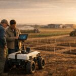
This spring, in a bright spot of optimism amid the encroaching salt, a group of University of Delaware students known as the “Salty Blue Hens” made national headlines in agricultural circles. They designed a robotic system to help farmers detect and manage saltwater intrusion – and their prototype was impressive enough to win the Judges’ Choice Impact Award (and a $2,500 prize from Google.org) at the 2025 Farm Robotics Challenge. The competition, held in early May and hosted by University of California Agriculture and Natural Resources and the AI Institute for Next Generation Food Systems, drew more than 20 college teams from across the U.S. and abroad. The Salty Blue Hens were UD’s first-ever entry, and they clinched an award recognizing the potential social impact of their project – a clear nod to the importance of safeguarding coastal farms.
At first glance, the team’s creation looks like something out of a futurist farm toolkit: it’s a two-part robot system combining aerial and ground vehicles. A drone equipped with a gamma-ray sensor flies over a field to map soil characteristics, detecting subtle variations in natural radioisotopes that correlate with soil types and moisture. Based on the drone’s data, the system then dispatches a ground robot to the spots of concern, where it automatically inserts a soil probe to measure salinity and moisture at the root zone. In essence, the drone provides a bird’s-eye survey of where salt might be creeping in, and the rover follows up with on-the-ground truth. By strategically targeting only the areas that need sampling, the system can dramatically reduce the manual labor required to monitor soil health across a farm.
Yin Bao, the team’s faculty advisor – who holds joint appointments in Plant & Soil Sciences and Mechanical Engineering at UD – said the challenge was a perfect sandbox for students from different disciplines to solve a real-world problem. “The students learned how to contribute their own knowledge and skills in an interdisciplinary team,” Bao noted, adding that they gained experience in agronomy, robotics, and remote sensing, and came to “really appreciate the positive impact of technology on improving farmers’ ability to make informed decisions… and alleviate labor shortages”. The project’s agricultural advisor, Jarrod Miller, is intimately familiar with the problem they targeted – he’s a UD agronomy specialist who has spent years working with coastal farmers and studying salt intrusion via drones and satellite imagery. Miller was impressed “with how quickly the team learned how to tackle the science behind saltwater intrusion and crop responses,” and said, “I believe they could take on a range of agricultural issues”. In other words, the ingenuity the students applied here could be extended to other farming challenges, from nutrient deficiencies to pest outbreaks, using a similar approach of mapping and targeted robotic sampling.
Precision Mapping the “Invisible” Salt
Why is the Salty Blue Hens’ approach such a big deal? To appreciate it, it helps to understand how farmers and researchers currently monitor salt intrusion – often, they don’t, at least not until the damage is severe. Traditionally, a farmer might notice poor crop growth in one corner of a field and suspect salt, then take soil samples with a hand probe, send them to a lab, and confirm salinity weeks later. But salt patches can be small and patchy (just a few meters across) or transient, appearing after a dry spell and fading after rain. Catching these early and across large acreages is labor-intensive and expensive. “Measuring the extent and severity of the impacts of saltwater intrusion through field-based methods is labour-intensive, time-consuming and expensive,” a group of scientists wrote in a recent study of Delmarva farms. Up to now, the cutting-edge approach has been to use satellite or aerial images to spot the signature white salt crusts on the soil surface, combined with machine learning to map them over thousands of hectares. In fact, that’s exactly what Pinki Mondal and colleagues did, using remote sensing to identify salt-damaged zones and even estimate economic losses. But even high-resolution satellite images can only detect salt once it’s visibly impacted the soil or crops. There is a need for finer detection – before a patch becomes a wasteland – and for ground-truthing what remote sensing suspects.
This is where the UD team’s marriage of drone and rover is particularly powerful. The drone’s gamma-ray sensor can scan a whole field in minutes, picking up soil density and composition signals that might indicate, say, a sandy patch that’s dried out (and likely saltier) versus clayey or wetter areas. It’s a technique borrowed from geological surveying – certain naturally occurring isotopes in soil emit gamma rays that a detector can pick up, and their levels can reveal soil type or even moisture. Using those aerial maps, the system’s AI directs the ground robot to roll out to specific coordinates and sample the soil directly for salinity. It’s precision agriculture taken to the next level: instead of blanket sampling or treating a whole field, the robot hones in on trouble spots identified from above. The result is a detailed salinity and moisture map of the field that would have been nearly impossible to obtain by old methods without enormous effort. “Within 30 seconds out in the sky, you can see the bad part of a field,” Jarrod Miller said of using drones to reveal salt damage that isn’t obvious at eye level. Patterns of stunted crops or soil variability jump out in drone imagery – and now those patterns can be acted upon immediately by a scouting robot.
Such technology could give farmers and land managers a crucial head start in adapting to salt intrusion. Instead of waiting until corn turns yellow or bare patches appear, a farmer could deploy a system like this at the start and end of each growing season (or after major storms) to pinpoint emerging salinity issues. The data might show, for example, that the back 5 acres of a field near a tidal creek are becoming marginal – allowing the farmer to adjust strategy on that section (perhaps planting a salt-tolerant cover crop there, or reducing fertilizer that would be wasted on compromised soil). Over time, repeated mapping could track whether interventions – like improved drainage or berms – are holding the line against the salt, or if the salty area is expanding. In the hands of cooperative extension agents or conservation planners, this kind of detailed soil health map could inform larger decisions as well. “This spatial information can help identify high-risk areas and better target resources and support to regions where transitions are occurring,” explains Rebecca Epanchin-Niell, a University of Maryland agricultural economist. In other words, policymakers could use it to decide where to invest in protections or which farmlands might need help transitioning to new uses.
Competing Solutions: Old-School Adaptation vs. High-Tech
Farmers aren’t waiting passively for robots to save them – in coastal communities, they have been experimenting with various adaptations for years. In parts of Maryland’s Eastern Shore, some growers have tried switching from corn to salt-tolerant crops like sorghum or barley, which can survive slightly higher salinity. Others are testing planting switchgrass or other salt-loving plants on the worst patches, essentially conceding those parts of fields to function as buffers or alternative crops (for biofuel or hay). Traditional coping methods include digging new ditches or improving drainage to flush salt out of soils after an inundation. In South Florida, where vegetable farms sit just inches above sea level, experts have suggested flushing fields with fresh water (if available) as a quick fix to push back saltwater. They also promote soil amendments – gypsum, biochar, compost – to help restore soil structure in salty fields, and even raised bed planting to keep crops’ roots above the salt-laden zones. Each of these methods can help in the short run, but they have limits. Flushing with fresh water is only feasible if you have fresh water to spare (and it risks wasting a precious resource). Switching crops can buy time, but as Mondal cautioned, “increasing salinity will eventually render the fields unfarmable even for salt-tolerant crops” if the trend continues.
What’s been missing in this arsenal is good, timely information. That’s where technologies for monitoring and early warning come in – and not just the UD team’s invention. Around the world, a nascent industry is developing tools to help communities see saltwater intrusion coming. In Vietnam’s Mekong Delta, for instance, local authorities have installed automatic salinity monitoring stations along canals that beam real-time data to farmers’ smartphones, warning when salt levels in irrigation water are approaching danger levels. One Vietnamese company’s system measures salinity, water level, pH and more, and then sends alerts via SMS and mobile app so that farmers can shut tidal gates or change water sources in time. This kind of “early detection and warning” approach parallels what the Salty Blue Hens aimed to do on land – both recognize that timely data is key. Similarly, scientists in California are experimenting with sensor networks and models to predict groundwater saltwater intrusion into coastal aquifers before it fouls irrigation wells.
Compared to these solutions, the UD salt-mapping robot occupies a unique niche. It’s not a stationary sensor network or a satellite algorithm, but a farm-scale, mobile system under the farmer’s (or agronomist’s) direct control. It acts almost like a bloodhound for salt: sniffing it out over large fields and zeroing in on hotspots. There are trade-offs, of course. A small farm would need to invest in or rent the equipment and have the know-how to operate it (though the student team worked to make the interface simple). But as robotics and drones become more common in agriculture, such a system could conceivably be operated by a custom service provider or a cooperative, the way crop-dusting or soil sampling services operate now. And the cost of drones and off-the-shelf robots is dropping; one of the sponsors of the Farm Robotics Challenge was Farm-ng, a maker of small robotic farm vehicles that student teams often build upon. In fact, many of the challenge entries were built on commercially available robot platforms with custom attachments. This means the leap from student prototype to real-world pilot might not be far off.
From Delaware’s Fields to Global Frontlines
Saltwater intrusion is not only a Mid-Atlantic or American problem – it is global, and growing. Roughly 20% of the world’s cultivated land and one-third of irrigated land is already affected by salinity, according to the U.N. Food and Agriculture Organization. This statistic includes places plagued by poor irrigation practices, but coastal sea-driven salinization is one of the fastest-growing threats. Nowhere is this more apparent than in low-lying delta regions of Asia, which produce food for hundreds of millions. In Bangladesh, for example, about 1.05 million hectares (over 2.6 million acres) of coastal land are currently salt-affected – nearly two-thirds of the country’s coastal farmland. Each year, an estimated 6,000+ more hectares of Bangladeshi farmland are overtaken by salinity and rendered less productive as rising seas push saltwater into the Bengal delta’s soils and rivers. Farmers there have had to adapt by shifting to salt-tolerant rice varieties, converting rice paddies into shrimp ponds, or even relocating inland when the land can no longer support agriculture. The Mekong Delta of Vietnam, another rice bowl of the world, faces similar challenges on an even larger scale. In 2020, a severe drought combined with record saltwater intrusion damaged about 57,000 hectares of crops and caused water shortages for hundreds of thousands of people. Researchers now estimate the Mekong Delta is incurring roughly $3 billion in annual losses due to salt intrusion’s hit on crops and aquaculture – an astonishing economic toll that is projected to climb even higher by 2050. In some provinces, the saltwater now penetrates 5–15 kilometers farther inland than it used to, meaning areas that once reliably grew rice are becoming too saline for a harvest.
These international experiences underscore a common thread: farmers everywhere need better tools to manage an increasingly saline future. Technology is poised to play a big role. In the Netherlands – a country famous for holding back the ocean – roughly one-quarter of the nation’s land lies below sea level, and even with advanced dikes, coastal Dutch farms are vulnerable to creeping salinization. Dutch researchers are experimenting with sensor-controlled drainage systems that flush salt from the root zone during high tides, and even breeding salt-loving potato varieties that can grow in brackish water. In places like Australia’s Murray-Darling Basin or California’s Central Valley, where soil salinity (often from irrigation) is a chronic problem, farmers have adopted electromagnetic soil scanners and remote sensing to map salt buildup, and they use sub-surface drainage lines to carry it away. What the University of Delaware students did aligns perfectly with this global movement: they created a nimble way to map and measure salt on farmlands, enabling precision intervention. As one judge at the Farm Robotics Challenge remarked during the awards (in an online ceremony) – the Salty Blue Hens project showed how robotics and AI can “empower farmers facing climate threats” by providing actionable data (awards ceremony, May 8, 2025).
The broader implications of such technology are stirring. If a relatively small team of students can develop this award-winning prototype, it suggests that with the right investment and support, we could soon see widely available tools for farmers to monitor soil salinity and other climate stressors. Government policy will play a key role in this transition from lab to field. Thus far, issues like saltwater intrusion have lurked in the background of agricultural policy, overshadowed by more immediate crises. But that’s starting to change. The USDA has established regional Climate Hubs that highlight saltwater intrusion as an emerging challenge and promote adaptation measures. State governments in affected areas are also taking notice – Delaware’s 2021 Climate Action Plan explicitly warned that “saltwater intrusion from sea level rise threatens Delaware’s farms and agricultural industry” and called for research and monitoring to guide protective measures. Providing cost-share funds or incentives for farmers to adopt resilience strategies (such as new drainage, salt-tolerant crops, or mapping technologies) could accelerate the response. There is also a conversation to be had about when to defend and when to retreat: in some cases, as tough as it is, the best option might be helping a farmer transition low-lying acreage out of production (for example, to restore it as wetlands that buffer other farmland). Such decisions will require good data and predictive tools – exactly what innovations like the Salty Blue Hens’ robot can furnish.
Back on the Delmarva Peninsula, the University of Delaware team’s triumph is still sinking in. They not only proved that a blend of robotics, agronomy and data science can tackle a problem once thought too diffuse and “invisible,” but they did so in a way that earned them national recognition. More importantly, they’ve added a spark of hope for farmers staring down the encroaching tides. Within a few years, one could see something like this being as routine as soil testing, with drones and rovers deployed after every high-tide flood to map salt damage. While the Salty Blue Hens’ invention is just a prototype, its real-world applications are on the horizon. With further refinement, such systems could be used not only in Delaware and the Chesapeake region, but anywhere that salt threatens agriculture – from the Louisiana bayous to the rice paddies of South Asia.
In an era when climate change often feels like an overwhelming tide, these students demonstrated the kind of ingenuity that can help communities adapt one field at a time. The challenges are immense – rising seas will continue to test the resilience of coastal farms across the U.S. and around the world. But as this salt-detecting robot shows, human creativity is rising to the challenge as well. By blending age-old agricultural wisdom (know your land, observe the changes) with 21st-century tech, we stand a better chance of holding back the salt – or at least outsmarting it. The “invisible flood” may no longer be invisible, thanks to the keen eyes of drones at 400 feet and the probing sensors of a little rover that’s unafraid to get its wheels dirty. And for the farmers whose livelihoods depend on staying one step ahead of encroaching seas, that knowledge could be salvation. As one might say in Delaware, this team of Blue Hens has given coastal agriculture something it desperately needs: a fighting chance against a salty future.